Main Streets
Main Streets
Calgary’s Main Streets are places where people come together. They are places where we want to go, we enjoy, and we connect as a community.
Program update – Fall 2023
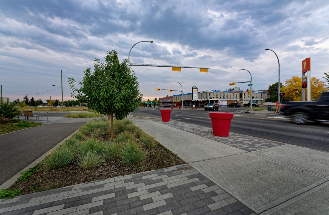
Improvements are officially complete along 17 Avenue S.W. and 37 Street S.W., and the new infrastructure is creating just the energy and street vibrancy envisioned as part of the Main Streets Program.
Of Calgary’s 24 identified Main Streets, 37 Street and 17 Avenue mark the second and third projects completed, following Bowness which wrapped in 2021. Marda Loop Main Street kicked off construction this past summer, while Bridgeland Main Street made impressive progress in its second year of construction. Check out their project pages for more information.
The 2023-2026 budget was approved with continued investments in the Main Streets program. Over the next four years, the Main Streets Program will focus on:
- Construction
- Bridgeland (Edmonton Trail N.E. / 1 Avenue N.E.)
- Marda Loop (33 / 34 Avenue S.W.)
- Advancing several other Main Streets through the strategize and design phases.
Stay connected
Subscribe to the Main Streets newsletter and receive project updates as milestones are met across the various projects.
Questions about the Main Streets Program?
Calgary's 24 Main Streets
In 2009, Calgary’s Municipal Development Plan identified 24 Main Streets as key transportation and commercial corridors. The streets were prioritized based on their potential to accommodate future urban growth, transit-oriented roads and mixed-use building types.
Improvements made under the Main Streets Program are meant to revitalize the heart of established communities and lay the groundwork for the future. They set communities up with the infrastructure that will support future development, businesses and increasing populations.
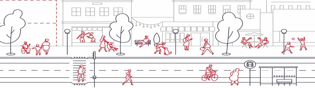
Main Streets accommodate a variety of commercial and residential building types and are enhanced by multi-model transportation networks and attractive streetscapes. They may also include additional uses and services, such as parks, recreational amenities and other public spaces for residents, workers, and visitors to gather. Streetscapes and amenities are designed to compliment the character of the surrounding community. As a result, Main Streets are the cultural, social and economic hearts of communities – a centre of public life, where people come to live, work and play.
Four core Main Street principles
Four principles function as the north star to ensure each Main Street is planned and holistically designed to honour our vision and common purpose, while also considering the many facets of a successful main street.
- Healthy and Social Lifestyle: A social and healthy environment creates a welcoming street. On the social side, the street is safe and accessible with opportunities for people to interact and gather. Healthy refers to both environmental health, like clean air provided through street trees, and opportunities for healthy behaviours, like walking, running, and cycling.
- Mobility and Functionality: The mobility and functionality principle focuses on the “street” part of a Main Street. Designs work to ensure the streets safely accommodate different modes and speeds of travel (such as walkers, cyclers, drivers or transit users) for people of all ages and abilities.
- Character and Identity: Main Streets with a strong character and identity are enjoyable, memorable, and unique streets. Character and identity can be achieved through tangible elements (e.g. heritage buildings and public art), programming (e.g. events), public amenities (e.g. benches or picnic tables), cultural diversity, and “bustle”, busyness, or energy. These features allow visitors, residents, and businesses to identify and “identify with” a specific Main Street. Together, these elements create a unique sense of place and offer memorable experiences for both residents and visitors.
- Economic Vitality: The businesses and uses along a Main Street give the street energy, and as a result promote economic vitality for surrounding community. Streetscape design, community activations and redevelopment opportunities encourage more people to work, live and play on Calgary’s Main Streets.
Main Streets improvements
Each Main Street has a unique scope and site specific design objectives, but all are meant to support the programs four core principles. These are typical improvements you may see on a Calgary Main Street.
Mobility improvements
Designs that allow pedestrians and wheelers (bikes, scooters, rollerblades) to safely share the roadway with vehicle traffic.
| Type of Improvement | Healthy & Social Lifestyle | Mobility & Functionality | Character & Identity | Economic Vitality |
|---|---|---|---|---|
| Improved pedestrian crossings |
|
|
||
| Signalized crossings |
|
|
||
| Multi-use pathways |
|
|
||
| Dedicated bike lanes and connections to adjacent pathways |
|
|
||
| Roadway improvements |
|
|
||
| Bike racks |
|
|
|
|
| Improved walking and wheeling connections |
|
|
|
|
| Vehicle lane adjustments |
|
|||
| Parking considerations |
|
|
||
| Accessibility improvements including wheelchair ramps and tactile plates |
|
|
||
| Traffic calming measures such as curb extensions, road narrowing or boulevards |
|
|
|
Public realm improvements
Enhancing public spaces and places where people of all ages and interests feel welcome.
| Type of Improvement | Healthy & Social Lifestyle | Mobility & Functionality | Character & Identity | Economic Vitality |
|---|---|---|---|---|
| Sidewalk widening & repairs |
|
|
|
|
| Pathways and improvements connections to parks and nearby amenities |
|
|
|
|
| Rest, gathering and social spaces |
|
|
|
|
| Benches, tables, planters, and other site furnishings |
|
|
|
|
| Tree, shrub & grass planting |
|
|
||
| Waste receptacles |
|
|
||
| Public art |
|
|
||
| Improved streetlighting |
|
|
||
| Green or natural stormwater infrastructure |
|
Public transit improvements
Designs that support integration of public transit systems.
| Type of Improvement | Healthy & Social Lifestyle | Mobility & Functionality | Character & Identity | Economic Vitality |
|---|---|---|---|---|
| Connections to existing transit lines and stops |
|
|
||
| Improved transit stops & laneway improvements |
|
Business support improvements
Improvements or designs that support the economies of local business.
| Type of Improvement | Healthy & Social Lifestyle | Mobility & Functionality | Character & Identity | Economic Vitality |
|---|---|---|---|---|
| Land use re-designations |
|
|
|
|
| Coordination with development applications |
|
|||
| Incorporating “spill-out” space into the streetscape design for patios, signage etc. |
|
|
|
|
| Parking considerations |
|
|
Five stages to Main Streets
Thoughtful planning and consideration go into the development and construction of each project. In 2014, The City launched the Main Streets Program and a five-stage approach that systemically plans and designs each street to ensure their full potential is realized.
While we would love to complete all Main Streets as soon as possible, completion of Main Streets is dependent on private funding, public funding, and City priorities – all of which can fluctuate year to year and council to council. As a result, projects exist in various stages and may take several years to advance to the next stage.
Stage 1 - Strategize
Strategize
This is where it all started. 24 streets within established communities were evaluated as Main Streets. All Main Streets have undergone two years of public engagement, economic market analysis and strategies for design and implementation have been outlined.
Stage 2 - Plan
Plan
The planning stage focuses on policy revisions that allow for higher population densities, a greater mix of building types, and more access to transportation options. Projects in this stage are going through land-use redesignations, local plan amendments and infrastructure capacity assessments. The Municipal Development Plan (MDP), local area plans, the Land Use Bylaw, and citizen input are all measured when considering policy revisions.
Stage 3 - Design
Design
The design stage includes three phases of public engagement and the development of a streetscape master plan.
Master plan drawings outline the project vision and conceptual designs for the proposed improvements based off feedback from the public engagement and alignment to the core principles.
Pending funding, construction drawings may be completed in this phase to get the project shovel ready.
Stage 4 - Build
Build
Once the design is complete and the project is funded, the Main Street moves into the build phase where it begins construction and community transformation is realized.
The build phase has two sub-phases: short term investments and permanent construction. Short term investments include community-focused pilot projects, test concepts and high need improvements. These can include traffic calming measures, temporary park space and pedestrian realm improvements. Permanent construction means the long term transformation of the main street based on the streetscape master plan.
Stage 5 - Live

Live
Once construction is complete, The City and the community will work together to ensure the vitality of the Main Street is upheld for generations to come. The City will commit to ongoing investments and maintenance as needed to ensure the main street continues to promote the four core principles of the Main Streets Program.
Frequently asked questions
What is a Main Street?
A Main Street is the cultural, social and economic focal point of a community. As the heart of the community, a Main Street is vibrant by design – they allow for a wider variety of uses (eg. Retail space and offices) and mixed housing options, to support the higher density of development necessary to support that variety of uses. Main Streets are places where people in a community can live and come together to enjoy a variety of activities.
Why do we need a Main Streets program?
To reach their full potential, Calgary’s Main Streets need both public and private investment. The Main Streets program is a continuum that goes from changes to land use that will support development opportunities to a streetscape master plan that is designed to support these changes and can be constructed in a coordinated fashion. The increase in development activity will bring more people and new jobs to the community, making the area more attractive to local businesses and residents.
What makes a vibrant Main Street?
A vibrant Main Street is resilient, adaptable and attractive. Main Streets capture the character of a community by being inviting, safe, attractive and memorable. They are diverse streets when it comes to commerce, residents and culture, featuring a mix of old and new and a land use framework that supports this diversity. This diversity is also supported by a multi-modal transportation network.
Which Main Streets are funded for construction?
Currently there are six Main Streets funded for construction. Depending on budget limitations some Main Streets are only funded for a portion of the design that will address the community’s highest needs.
- 37 Street Main Street
- West 17 Avenue Main Street
- 33/34 Avenues S.W.
- Montgomery (Bowness Road) Main Street
- 1 Avenue N.E.
- Centre Street N. (funded through Green Line)
Due to budget limitation, some of the above Main Streets will be constructed in phases or short-term improvements that address the community’s highest needs may be implemented.
Why is my Main Street not currently funded for design and construction?
The Main Streets program team has identified five Main Streets as current priorities. Once these Main Streets have been seen through to completion, we will work with Council to determine whether funding can be allocated to the next group of prioritized Main Streets.
Documents, reports and links
Main Street Program
Main Street locations
1 Avenue N.E.
- Bridgeland Area Redevelopment Plan
- Strategize Phase – What We Heard Report – 2015
- Strategize Phase – Local Viewpoint Map - 2015
- Planning Phase – What We Heard Report – 2016
- Planning Phase – Land Use Changes/Character Home Incentive District – 2017
- Design Phase – What We Heard Report – June 2018
- Design Phase - What We Heard Report - March 2019
- Design Phase - What We Heard Report - July 2019
- Design Phase - Streetscape Master Plan
10 Avenue S.W.
10 Street N.W.
14 Street S.W.
- Hillhurst/Sunnyside Area Redevelopment Plan
- Sunalta Area Redevelopment Plan
- West Village Area Redevelopment Plan
- Beltline Area Redevelopment Plan
- South Calgary/Altadore Area Redevelopment Plan
- Bankview Area Redevelopment Plan
- Lower Mount Royal Area Redevelopment Plan
- Upper Mount Royal Area Redevelopment Plan
- Strategize Phase – What We Heard Report – 2015
- Strategize Phase – Local Viewpoint Map - 2015
16 Avenue N
- 16 Avenue North Area Redevelopment Plan
- Strategize Phase – What We Heard Report - 2015
- Strategize Phase – Local Viewpoint Map (Banff Trail/Capitol Hill/Hounsfield Heights-Briar Hill) – 2015
- Strategize Phase – Local Viewpoint Map (Mount Pleasant/Rosedale/Crescent Heights) – 2015
- Strategize Phase – Local Viewpoint Map (Tuxedo/Mountview/Renfrew) – 2015
16 Avenue N.W. (Montgomery)
17 Avenue S.E.
17 Avenue S.W.
- Killarney-Glengarry Area Redevelopment Plan
- Richmond Area Redevelopment Plan
- Strategize Phase – Local Viewpoint Map (Crowchild Trail-37 Street) – 2015
- Strategize Phase – Local Viewpoint Map (14 Street-Crowchild Trail) – 2015
- Strategize Phase – Local Viewpoint Map (MacLeod Trail-14 Street) – 2015
- Planning Phase – What We Heard Report – 2016
- Planning Phase – Land Use Changes – May 2017
- Design Phase – What We Heard Report (Crowchild Trail-37 Street) – September 2018
- Design Phase - What We Heard Report - February 2019
- Design Phase - Streetscape Master Plan
32 Avenue N.E.
33/34 Avenues S.W.
- Marda Loop Area Redevelopment Plan
- Richmond Area Redevelopment Plan
- South Calgary Area Redevelopment Plan
- Strategize Phase - What we Heard Report - 2015
- Strategize Phase - Local Viewpoint Map - 2015
- Planning Phase – What We Heard Report – May 2018
- Planning Phase – What We Heard Report – October 2018
- Design Phase – What We Heard Report – March 2018
- Design Phase – What We Heard Report – May 2018
- Design Phase – What We Heard Report – October 2018
- Design Phase - Streetscape Master Plan - 2019
36 Street N.E.
37 Street S.W.
- Killarney-Glengarry Area Redevelopment Plan
- Richmond Area Redevelopment Plan
- Strategize Phase – What We Heard Report – 2015
- Planning Phase – What We Heard Report – 2016
- Planning Phase – Land Use Changes – May 2017
- Design Phase – What We Heard Report – March 2018
- Design Phase - What We Heard Report - February 2019
- Design Phase - Streetscape Master Plan
4 Street N.W.
4 Street S.W.
50 Avenue S.W.
9 Avenue S.E.
- Inglewood Area Redevelopment Plan
- Strategize Phase – What We Heard Report – 2015
- Strategize Phase – Local Viewpoint Map - 2015
- Design Phase – What We Heard Report – May 2017
- Design Phase – What We Heard Report – August 2017
- Design Phase – What We Heard Report – February 2018
- Design Phase – Streetscape Master Plan – June 2018
Bowness Road N.W. (Bowness)
Bowness Road N.W. (Montgomery)
- Montgomery Area Redevelopment Plan
- Strategize Phase – What We Heard Report – 2015
- Strategize Phase – Local Viewpoint Map - 2015
- Planning Phase – What We Heard Report - 2016
- Planning Phase – Land Use Changes – May 2017
- Design Phase – What We Heard Report – March 2018
- Design Phase – Parking and Driving Feedback Map – March 2018
- Design Phase – Walking, Transit and Cycling Feedback Map – March 2018
- Design Phase – Placemaking Feedback Map – March 2018
- Design Phase – Streetscape and Safe Public Spaces Feedback Map – March 2018
- Design Phase - What We Heard Report - March 2019
- Design Phase - What We Heard Report - June 2019
- Design Phase - Streetscape Master Plan - 2019
Centre Street N.
- Crescent Heights Area Redevelopment Plan
- North Hill Area Redevelopment Plan
- Strategize Phase – What We Heard Report - 2015
- Strategize Phase – Local Viewpoint Map (16 Avenue to McKnight Boulevard) – 2015
- Strategize Phase – Local Viewpoint Map (Bow River to 16 Avenue) – 2015
- Design Phase - What We Heard Report - April 2019
Edmonton Trail N.E.
- Crescent Heights Area Redevelopment Plan
- Bridgeland/Riverside Area Redevelopment Plan
- North Hill Area Redevelopment Plan
- Winston Heights/Mountview Area Redevelopment Plan
- Strategize Phase – What We Heard Report - 2015
- Strategize Phase – Local Viewpoint Map (Bow River-16 Avenue) – 2015
- Strategize Phase – Local Viewpoint Map (16 Avenue-32 Avenue) – 2015