Calgary Planning Commission Teacher's Guide
This is a video series for teachers of students in grades two through seven focusing on historic milestones in the last century of Calgary’s development. We designed the videos to complement existing topics in Social Studies, as they explore history, civic government and the characteristics of our communities. These videos were created in recognition of Calgary Planning Commission's 100th birthday.
Activity exercises are included to help students understand and appreciate Calgary’s unprecedented growth and forward-thinking approach to planning.
The videos feature historic buildings, historic sites, and new developments which have made Calgary the vibrant city we see today. Our goal is to bring these city-building achievements to the classroom.
Alberta Curriculum Connections
The video’s accompanying activities align with the Province of Alberta Programs of Study in Social Studies for grades two through seven. Embedded within the activities are strong connections to the Language Arts Program of Studies with emphasis on skills including listening, speaking, reading, writing and research. The activity exercises support an inquiry-based approach where teachers are looking at an essential question or idea such as legacy, beauty or identity.
Video Playlist
Each video episode includes historical information about Calgary and works with the corresponding class activities listed below.
Videos 1 - 6
Episode One - Welcome to the Boomtown, Buster (1911 - 1929)
Video Discussion Topics
- Why were the Bow and Elbow Rivers important to the development of Calgary?
- How did the arrival of the Canadian Pacific Railway (CPR) contribute to Calgary's development?
- How does this compare to the impact of the oil industry on Calgary today? What other events/industries have contributed to Calgary’s development?
- What was the role of the Calgary Town Planning Commission in 1911? What are the similarities and differences today? Why would a Planning Commission be important?
- Alexander Calhoun was one of the original members of the town planning commission - what else is he famous for?
- Review the Thomas Mawson plan. How would Calgary have been different had this plan gone ahead?
- Why was housing such an important issue at this time? What is different about housing today?
- What evidence do you see of forward thinking decisions made during the 1911 - 1929 periods?
Suggested Activities
Please see activities 1, 2 and 3.
Debate and Deliberate
Should cost override design? (examples: LRT, Airport Tunnel or Peace Bridge)
Episode Two - Frankly My Dear, Let's Build A Dam (1930 - 1946)
Video Discussion Topics
- What is a 'boom'? A 'bust'?
- What were the challenges of Calgary's construction industry in the 30's?
- What are some examples of initiatives that have significantly changed the face of Calgary? (i.e. Glenmore Dam, Currie Barracks, upstream dams, airport, etc.)
- Why is the dam so important to our city today?
- Although World War II took place a long way from Calgary, what impact did it have on our city?
- What evidence of the Canadian Forces do you still see in Calgary?
- What have you learned about the zoning bylaws in Calgary?
- Why are zoning bylaws important?
- How did the Calgary Planning Commission contribute to Calgary’s development? Do you see evidence of this today?
- When was your neighbourhood developed?
Suggested Activities
Please see activities 4, 6 and 7.
Downloads
Essential Research Sources
Calgary Districts: A Research Guide
Debate and Deliberate
Investigate the redevelopment of Currie Barracks into Garrison Woods. If you could redesign your neighbourhood, what would you do?
Field Trip Ideas
Heritage Park, Downtown, Inglewood, City of Calgary Archives, Calgary Public Library, Calgary Bridge Tour
Episode Three – It Came From North Hill Mall (1947 – 1960)
Video Discussion Topics
- Compared to earlier years, life in Calgary is prosperous during this era. Why?
- What impact did the discovery of oil at Leduc have on Calgary? How does this compare to when the Canadian Pacific Railway arrived in Calgary?
- What was the "normal school" used for?
- Compare the design of neighbourhoods during this time to those of earlier housing developments. What do you notice? How has your community been designed?
- Between 1947 and 1955 there were 60,000 homes built in Calgary. What does that tell you?
- How did the construction of the North Hill Mall change our views about shopping?
- How have cars changed the way we do things?
Suggested Activities
Please see activities 1 and 4.
Debate and Deliberate
Are old buildings worth saving? What is the current status of the Barron Building?
Compare our shopping habits to those of people in another country. What are the differences? Why do you think this is?
Episode Four - Towers of Industry (1961 - 1980)
Video Discussion Topics
- How did cars impact Calgary's development and culture?
- Look closely at the History of Annexation Map. When did your community become part of Calgary?
- What changes occurred during this time to the Planning Advisory Committee?
- As a city grows, does it continue to be "one place" or many? (i.e. downtown vs. suburbs, where we work vs. where we live. Where do you prefer to live?
- Why was this period an important time in Calgary's cultural history?
- Does public art matter? Investigate Calgary's Public Art Policy.
- What other initiatives has the City undertaken over the years to celebrate the arts?
- Should people be encouraged to come downtown? Why or why not?
- What contributed to the loss of Calgary's historic buildings? What is different today?
- What makes Calgary so vulnerable to recession? Is this different in other cities?
Suggested Activities
Please see activity 1.
Debate and Deliberate
Investigate Calgary's Should Calgary continue to annex land from surrounding areas? What are the alternatives?
Field Trip Ideas
Take students downtown to view the city from the Calgary Tower.
Episode Five - It's All Fun and Games (1981 - 1996)
Video Discussion Topics
- Why is it important for a city's downtown to be vital? Should we replace or preserve old buildings?
- In what ways can we participate in the revitalization of existing communities?
- What purpose does a ring road serve?
- What are "self-contained" communities? What could they look like? What are the benefits? What are the drawbacks?
- How can we sustain our environment and maintain the vitality of our city?
- How would reducing our dependence on cars impact the way we design and live in our city?
- What is a LEED building? Give some examples of LEED buildings in Calgary.
- What is your vision for our city? What initiatives would you include in your plan? How will you share it?
Suggested Activities
Please see activities 3, 4 and 5.
Debate and Deliberate
- Should we build 'up' or should we build 'out'?
- Public transit or new roads? What does that mean for Calgary?
- Research Project: What is worth saving? Heritage buildings or new?
Field Trip Ideas
- City Hall School
- Ralph Klein Legacy Park,
- City of Calgary Water Centre,
- Cardel Place
- The Bow office tower
Activity List
Each classroom activity accompanies the video episodes. They are intended to assist teachers with guiding conversations about city planning.
Activity 1 – Looking Deeply
These questions may be used with children to help them talk about art, buildings and photographs.
Begin by taking a few moments to imagine that you are part of what you are looking at. Think about where you are in relation to the picture. Use all your senses to interpret your experience.
- What do you see?
- What do you feel?
- What is happening in the picture?
- What does this picture remind you of?
- What do you wonder?
- What might be going on in the picture that you cannot see?
- What is missing in the picture?
- Does this inspire you to create something? What?
- Describe what you see. Tell me about lines, shapes, colours, textures and materials used.
- What’s the first thing that catches your eye?
- How is everything put together?
- Is one colour, shape or object more important than the others? Why?
- Imagine you are in this picture. What do you hear? Smell? Taste?
- Does this image tell a story?
- Is it a good place to be? Why?
- What do you like the most about it?
- Would you change anything?
- Where would you most like to be in the picture? Why?
- Some of the objects in the image are still and some are moving.
- Can you tell which ones they are? How do you know?
- List three words that would describe the sky, the water, etc.
- Does this picture feel warm or cold?
- What clues tell you which season is depicted in the scene?
- Look closely at the textures. Find a place where they are uniform. Find a place where they seem random. Why do you think they are different?
- Would you say this image is exciting, dull, quiet, sad or happy? Why?
- Do you agree with what others have said about the image? Write about your thoughts.
The questions above are adapted from the following sources:
Blizzard, Gladys S. (1996). Exploring Landscape Art with Children. New York: Lickle Publishing.
Ernst, Karen. (1999). “How to Read a Painting.” Teaching K-8, September, 1999.
Ernst, Karen. (1999) “Pictures as Storyboards” Presented for Early Literacy, February, 2000.
“Looking At Art,” The Chevron Glenbow Museum School as adapted from Feldman, Edmund Berke. (1970).
Becoming Human Through Art: Aesthetic Experience in the School. New Jersey: Prentice Hall
Activity 2 – Building a community
This is an open-ended activity to encourage students to consider what makes a community and the issues inherent in its development and expansion. Discussion points can be approached in any order.
Materials
- Large paper strip (at least 1 metre x 4 metres) taped to wall.
- Colour markers.
Process
- Begin by drawing in a river system (teacher may choose to draw the confluence of the Bow and Elbow rivers).
- Discuss with the students why this might be a good place to establish a community.
- Discuss the sequence of events as people began to arrive at the site.
- Brainstorm: What did the people need?
(Students begin to sketch structures on the large paper as they are identified.)
- shelter
- food
- other goods
- services (fire, health, safety, education, etc.)
- wellness and entertainment (public spaces, recreation, parks, theatres, places of worship, etc.)
As structures are added, encourage students to think about:
- How do people get from place to place?
- How do they cross the river(s)?
- Where should businesses and services be located relative to housing?
- Wellness and entertainment facilities?
Points to consider
- How do we connect with other communities?
- Do we share services and facilities?
- What impact does the type of transportation have on how the community develops? (cars/roads vs. transit oriented development).
- What impact might mixed-use buildings have on how the community functions?
- Consider the ratio of structures added to the drawing (i.e. Do we need more housing than businesses?).
- Is there a variety of structures in our community? (e.g. bridges, buildings, schools, etc.)
- Do people have housing options? (e.g. single-family, condos, apartments, etc.)
- What can we do to enhance our community? (e.g. trees, public art, performing arts)
- Does the climate in our community impact the way we do things?
- What else does our community need?
- What impact does the arrival of more people have on our community?
This can lead into the development of a “Block City” where students build a 3-D model of their community.
Helpful links
History of Calgary
City Creator
Activity 3 – Utterly Utopian
In this activity students will examine what their idea of a perfect society is and then design their own utopian city.
Concept: Is utopia possible?
Objectives
Students will examine the history of utopian societies and will analyze the novel The Giver to determine if this society is fair and just. Students will examine the differences between Jonas’ society and our society today in terms of career choices, a society with no competition, individuality, and the relationship between equality and justice.
Activities
1. Create a mind map showing the relationships of a utopian society (teacher-led).
2. Imagine that you have been hired to plan and create an ideal city.
- Give your perfect community a name, a system of government, a physical description, and an account of how people spend their days.
- Think about how that community would change and grow.
- What roles would history and memories of painful events play in the growth of the community?
- Think about what would have to be added to our own society to make it perfect?
- What would be lost in this quest for perfection?
- What are the rules or laws?
- What happens if someone breaks them?
- How would these rules affect individuals? Schools? Families? Government? Include as many details as possible.
- How do our travel experiences or global awareness impact how we design our cities?
3. What are some of the problems that we face in our city today?
- List three. Illustrate how you would solve at least two of them. Encourage students to demonstrate their learning through a media of choice.
4. Write a persuasive essay: Can utopia exist?
5. Consider the question, “What is beauty?”
- Explore beauty in many forms (e.g. music, dance, visual arts, design, the natural world, etc.).
- Ask students to choose an area of passion and articulate why they have chosen that form of beauty as an ideal.
Evaluation
Using a rubric, students are graded on their ability to add a personal voice; organize their work; employ appropriate sentence structure, flow and rhythm; focus on the topic, choose appropriate vocabulary, punctuation and grammar; and demonstrate a conclusion.
Activity 4 – Discover your community
This activity may focus on the community where the students live, or could be directed toward the common community where students go to school. These activities can be modified to ensure grade-level appropriateness.
Objectives
Students will understand:
- Each community has a unique essence or feel.
- Each community has its own history and character.
- The fundamental nature of community character depends on its residents, businesses, and institutions.
- We all play a part in influencing our community and our city.
Suggested activities
1. Write down everything you know about your community. Share this with a classmate or a small group. Create a class chart of common understandings.
2. Provide students with a writing journal and take them on a walk around their community. Allow time for student sharing following the excursion. Ask them to focus on the following:
- What sounds do you hear in the community?
- What tastes can you find in the community?
- What smells do you associate with the community?
- What does the community look like? What doesn’t it look like?
- What landmarks do you notice in your community? Why are they there?
3. Look at a map of your community to answer these questions:
- In what part of the city is your community?
- Which communities are connected to yours?
- What did your community look like 10 years ago? What about 15, 50 or 100 years ago?
- How has it changed?
4. Five Ws + How
- What is your community most famous for, or what should it be famous for?
- Where in the community do people go to feel good?
- When is the community most enjoyable? Most annoying?
- Why do people live here?
- What are some challenges that your community faces?
- How would we change the community if we could?
5. What if? Questions
- What if this community didn’t exist? Where would we go to school?
- What if our community was rezoned? How would it change?
- What if the community won an award of many millions of dollars?
- What could be done with the money to improve the community?
6. Find out about events in your community by exploring local newspapers, community newsletters, the internet and signs posted in your neighbourhood.
7. Think about your community as part of the whole city. Consider the following activities:
- A city marks its history in many ways... from carvings, to statues to memorials. Explore your community and beyond to discover historical landmarks.
- Most cities are in a constant state of change. What clues do you see that tell you this is happening?
- The land a city is built on, or a wall can provide an opportunity to see the historical and geological layers of our city. What do you notice?
- What happens if you overlay a map of a different city with Calgary?
- What about fictional cities?
- Choose one small block of streets in your community and walk them again and again in every possible direction. What do you know that you didn’t know before?
- Think of one specific area where you live and list all the street names and signs that you can remember.
- Take a walk and make note of places you missed or maybe hadn’t noticed before.
- Look for messages in the city — on signs, posters, walls, in graffiti.
- Create new signs for your city. What is important for citizens to know?
Almost every day we leave our homes and head out to another destination. It may be to school, a friend’s house or to a store. When we are going from one place to another, how often do we really pay attention to the community that we live in?
Activity 5 - It didn't just happen!
Use the following “Inquiry Survival Guide” to research what makes Calgary a unique and successful city.
Inquiry Survival Guide
What has shaped Calgary’s identity?

The challenge
Over the last several weeks, you have been learning about Calgary’s early history, planning and development. You have practiced looking deeply at landmarks in the city and discovered new information about your own community. Now is your chance to really figure out what it means to be a Calgarian!
Use the following Inquiry Survival Guide to research a period of time in Calgary’s development that you believe was the most important in making our city what it is today.
When you are finished, you will have created a one- or two-minute video clip that will leave no doubt in the minds of your audience that your pick is, in fact, the reason we are who we are.
Timeline to guide the inquiry process
- When will I start my planning?
- When is my initial research due?
- When will I do my refocus?
- When is my final research due?
- When will I start creating?
- When is my final product due?
- When will I share my final product?
- When will I evaluate my inquiry?
What steps do I need to take to begin this process?
- Ask questions about Calgary, the people, history and changes that will guide my inquiry.
- Organize my materials for learning:
- Complete “Information Retrieval Plan”
Information Retrieval Plan
1. Which period of time would you say was the most influential in Calgary’s history and how has it shaped who we are today.
2. Statement of advocacy:
“I believe that _____________________________________ made us who we are as Calgarians today.”
3. Specific questions to guide the inquiry process:
- What period of time do you believe was most important in Calgary’s history?
- Who were the important people during this time?
- What important world events took place during this period?
- What were the significant changes to Calgary?
- What were some important challenges or barriers faced by Calgarians?
- How did this contribute to Calgary’s identity?
Refocus checklist
- Is there enough information to complete the project?
- Does the information I’ve gathered answer the questions I’ve asked?
- What conclusions can be drawn that are appropriate to the findings, reflect my own understanding and are relevant to the topic?
- In what ways does this research meet the context of the assignment?
- What new questions have emerged from the research that need to be answered?
- How does the research refocus the assignment?
- What other information needs to be added?
- What is the best source for this information?
- How can this information best be used for an effective project?
Inquiry Rubric

Activity 6 - Calgary Bridge Tour
Bus tour of bridges and downtown buildings
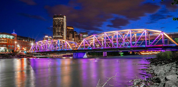
Stop 1: Peace Bridge
Stop 2: Prince’s Island Bridge
Stop 3: Centre Street Bridge.
Stop 4: The Confluence Historic Site & Parkland (previously Fort Calgary): two bridges are at this location
- Inglewood Bridge
- The Confluence Historic Site & Parkland (previously Fort Calgary) pedestrian bridge
Additional stops:
- Reconciliation Bridge old (truss bridge)
- Reconciliation Bridge new (beam bridge — Fourth Avenue Flyover)
There are many options for this trip, and you may choose to alter the sequence and/or the bridges visited.It is highly recommended to view fewer rather than more bridges in a single trip.
Before you go
- Plan to visit the bridges on your own before taking your students and be sure to take some photos for reference.
- Decide what the focus of your visit will be at each stop.
- Create a “base” area using coroplast, plywood, or similar rigid material on which you have drawn the Bow/Elbow rivers within the downtown core (blue mactac works well for the rivers).
- Collect construction materials for building structures.
Activity 6 - Calgary Bridge Tour
Bus tour of bridges and downtown buildings
Stop 1: Peace Bridge
Stop 2: Prince’s Island Bridge
Stop 3: Centre Street Bridge.
Stop 4: The Confluence Historic Site & Parkland (previously Fort Calgary): two bridges are at this location
- Inglewood Bridge
- The Confluence Historic Site & Parkland (previously Fort Calgary) pedestrian bridge
Additional stops:
- Reconciliation Bridge old (truss bridge)
- Reconciliation Bridge new (beam bridge — Fourth Avenue Flyover)
There are many options for this trip, and you may choose to alter the sequence and/or the bridges visited.It is highly recommended to view fewer rather than more bridges in a single trip.
Before you go
- Plan to visit the bridges on your own before taking your students and be sure to take some photos for reference.
- Decide what the focus of your visit will be at each stop.
- Create a “base” area using coroplast, plywood, or similar rigid material on which you have drawn the Bow/Elbow rivers within the downtown core (blue mactac works well for the rivers).
- Collect construction materials for building structures.
Peace Bridge
Description
Pedestrian tubular truss bridge
Access
Memorial Drive on north side of the Bow River
Why it was built
The City of Calgary proposed a bridge connecting the south Bow River pathway and downtown Calgary with the north Bow River pathway and the community of Sunnyside.
Why that design
The Peace Bridge was designed by Spanish architect, sculptor and structural engineer Santiago Calatrava. The design follows strict requirements imposed by The City, with no piers in the water (to minimize the ecological footprint) and height restrictions (due to the vicinity of the Calgary City/Bow River Heliport).
Features
- Helical steel structure with a glass roof.
- Increased width of 6.2 metres to accommodate both pedestrians and cyclists.
- Segregated bicycle and pedestrian traffic.
- Lighting for nighttime use.
Material
- Steel arches.
- Reinforced concrete for the abutments & deck.
How it works
The bridge gets its strength from a combination of the material (structural steel) and the use of the triangle, a very rigid shape. Beams attached at the bottom carry the load from the road to the trusses and they in turn to the pier and abutment.

Prince’s Island Bridge
Description
Cable stay/beam bridge
Cable stay is a relatively new, popular design — a suspension bridge without anchors. The cables are strung from the tower to the deck.
Access
Buses are permitted to park at The City of Calgary parking lot next to the Calgary Curling Club on Memorial Drive.
Why it was built
To provide pedestrian access from the community of Sunnyside to Prince’s Island and the downtown core. With no existing pedestrian access on the lower deck of Centre Street bridge, a crossing was needed between 10th Street N.W. and Edmonton Trail.
Why that design
Cable stay design allows a 67-metre span over the Bow River that avoids the need for pier support. Pier construction in a waterway can be expensive and disruptive to the environment.
Features
- A-shaped tower supports the stay cables.
- One long span over the Bow River with short spans (beam bridge) at the north and south ends.
- Expansion joints at each end of the bridge covered with steel plates. This allows the bridge to lengthen and shorten with changes in temperature.
- Bridge moves under pedestrian traffic.
Material
- Concrete abutments and piers.
- Steel box girders (beams), steel tower and steel plate deck covered in concrete.
- Steel cables.
How it works
The steel cables support the roadway (deck) and transfer the load (force) to the top of the tower. The tower transfers this force into the footing (foundation). The footing (foundation) pushes back and holds the bridge stable. The cement piers are stationary and provide stability.

Centre Street Bridge
Description
Seven-span arch bridge of varying heights. The four north spans are the originals.
Access
Sien Lok Park on Riverfront Avenue
Why it was built
Built in 1906 (steel beams and wooden deck) to replace the ferry service, this was originally a privately-owned toll bridge. It collapsed in a flood and was rebuilt in 1916. It was renovated and restored in 2000.
Why that design
Discuss this with the students — reason unknown.
Features
- Its size and grand design.
- Kiosks with lion statues in all four corners.
- Large concrete arches supported by massive piers (abutments) – Skewed twin arches.
- Lower level bridge suspended from beams under the main deck.
- Lions designed by J. Thomson (famous for Banff Indian bridge heads).
- Look for buffalo carvings.
- Bridge extends over Memorial Drive (north) and Riverfront Avenue (south).
Material
Concrete bridge — Lions were originally sandstone. Where are these now?
How it works
Concrete arches provide support for both upper and lower decks. The weight (load) is transferred along the arches to large concrete piers (abutments).
The Confluence Historic Site & Parkland (previously Fort Calgary) Bridge
Description
Suspension bridge
Access
Bus drop off is available at the The Confluence Historic Site & Parkland (previously Fort Calgary) parking lot. As students walk to the bridge, they can look at the structure of the fort.
The bus can then pick up students along Sixth Street at Fifth Avenue.
Students can also check out the Inglewood truss bridge across the Elbow River. For information on truss bridges, see the section about the Reconciliation Bridge.
Why it was built
To connect the multi-use pathway with St. George’s Island.
Why that design
River piers are expensive to construct. By building a suspension bridge, the main span can be long enough to keep both piers on each bank of the river. Suspension bridges are very attractive and make excellent park or pedestrian bridges.
Features
- Two H-shaped frame towers on each side of the river.
- No pier in the river.
- Steel truss under main span gives some rigidity so that it can resist wind forces.
- Large concrete foundations anchor the cables at each end of the bridge.
- Bridge moves under pedestrian traffic.
Material
- Concrete abutments, tower foundations.
- Steel rod suspension cables and wire rope hangers.
- Timber deck.
How it works
The wire rope hangers pick up the load along the span and transfer it to the suspension cables. These cables in turn transfer the load to the towers and to the anchors. The bridge is supported by the towers and by huge cables anchored to the ground.

Reconciliation Bridge
Description
Truss bridge, two-span truss
Access
Fifth Avenue and Eighth Street S.E. cul de sac. Students can walk from the The Confluence Historic Site & Parkland (previously Fort Calgary) pedestrian bridge.
Why it was built
This bridge was originally built in 1890 from timber to serve the settlers that lived northeast of town. By the turn of the century the timber bridge had become run down from horse and wagon traffic.
- A new bridge was planned and constructed in 1910.
- One major overhaul in 1972 added a concrete deck.
- It remains a key river crossing today.
Why that design
Popular in the late 1800s and early 1900s particularly with the railway requiring greater strength for shipping across Canada.
Features
- The superstructure, or the truss itself – a mosaic of triangles creating a strong structural frame.
- Two independent bridges joined over a pier.
- One pier in river.
- Large steel gusset plates, bolts and rivets that hold them together.
- Sidewalks are supported on the bridge using triangles.
- Cables and pipes (utilities) tucked under the deck.
- Note sliding bearings at the south abutment and the large steel plates that the truss rests on.
Material
Concrete abutments, pier and deck.
Structural steel truss and beams.
How it works
A combination of the material (structural steel) and the use of the triangle, a very rigid shape, give this bridge its strength. Beams attached at the bottom carry the load from the road to the trusses and they in turn to the pier and abutment
Back at school - teacher directed activity
- Ask students to name the bridges and buildings downtown that they noticed on the field trip and list these on paper (e.g. The Confluence Historic Site & Parkland (previously Fort Calgary), churches, fire stations, Calgary Tower, Centre Street Bridge, etc.).
- Group students (3–5 per group).
- Ask students to decide as a group what they would like to construct (offer two choices for bridges and two choices for buildings). Try to encourage a variety of structures so that all are represented upon completion by the whole class.
- Go through possible materials for construction.
- Ask students to create a sketch of their structure labelled with possible materials they might use to create a blueprint of their bridge/building.
- Begin construction (this may take two to three days).
- As each group finishes, add the structures to the base in the appropriate location.
Helpful links
Activity 7 - This old Calgary house
Information is available from a variety of sources if you are interested in researching the history of an old building in Calgary.